Looking to the Future
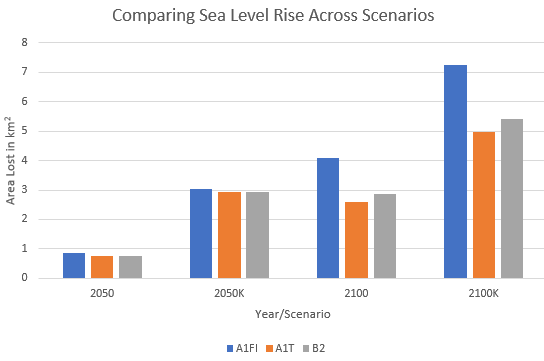
It is clear looking at the result of this analysis that Vancouver will be hit with sea level rise over the next century. The scale at which the impacts will be felt is still to be determined depending on which pathway humanity decides to take. As it stands, it looks like we are on the way to an A1FI (fossil fuel dependent scenario) world based on current emission projections and global (in)action. What is clear from these results is that pursuing alternative pathways (A1T or B2) leads to a significant reduction in sea level rise and the amount of land lost. For the City, it is worthwhile to continue to push for a future that follows an alternative scenario. Landowners along the shore should be especially concerned with the impacts of sea level rise as it may mean that expensive mitigation measures may need to be purchased or abandoned completely. Mitigation measures include additional protection (levees), raised property or abandoning existing property (City of Vancouver, 2018). The extensive flooding for our “Limited Agriculture” land may reduce our ability to be food secure and the flooding of industrial areas may mean that we need to relocate business. Moreover, extensive Single Family Zoned properties and Comprehensive Development sites (mixed-use, with both residential and commercial space) are at risk under rising sea levels. The City and property owners will need to plan for mitigation to protect livelihoods and relocate individuals if needed.

A1T versus B2
What was the most interesting outcome of this analysis was the difference (or lack thereof) between A1T and B2. To review: A1T is the renewable energy/technological innovation pathway driven at a global level and B2 focuses on local and regional actions. The difference between the two scenarios in terms of sea level rise and temperature increase is minimal. Therefore, Vancouver’s local sustainability goals and Metro Vancouver’s regional goals may be a good model for achieving global sustainability through local and regional actions.
Study Limitations
There were a few limitations to this study. Firstly, the University Endowment Lands (UEL) were excluded from this study due to a lack of data. The DEM from the City of Vancouver only extends into Vancouver proper. The result is that the western boundary of Vancouver is misclassified as water because any area that returned a 0 was classified as water. Secondly, Vancouver does not have a “Parks” zoning instrument and therefore the vast majority of parkland is classified as RS-1 (single dwelling unit). Because most of Vancouver’s coastal land is parkland (beaches, walking trails etc.), this lack of data overexaggerates the impacts on single family homes and does not accurately describe the impact on parkland. If this study were to be refined in the future, I would get more data on Vancouver’s parkland to evaluate the impacts on public property. I would also see if there is DEM data available for UEL to evaluate sea level rise in order to fully evaluate Vancouver’s geography. Finally, I could have looked at the impact of sea level rise on individual properties instead of zoned areas. However, I limited the scale and scope of this project to make it more manageable.
References
City of Vancouver. (2018). Vancouver’s Changing Shoreline | Preparing for Sea Level Rise. Retrieved from https://vancouver.ca/files/cov/vancouvers-changing-shoreline-june-2018.pdf